Simple And Cost Effective Solutions for Survey Engineering Drawings
E Surveying Solutions in its pursuit for cost effective solution in civil engineering have developed easy to use solution for Section Generation, Interpolation, Contouring, Earthwork Calculation and Converter Survey data from Total Station data in to CAD Drawing. It is extremely beneficial to Surveyors/Consulting Firms/ Infrastructure Companies/ Engineering Colleges/CAD Services/CAD Training Institutes and Govt. Organizations.
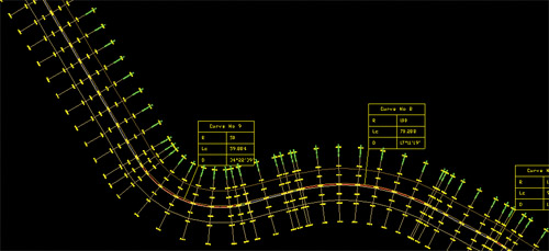
Section & Interpolation
Using ESS Products - Sections module, Sections related to Road/ Railway Lines/Irrigation Canal can be created either from Excel data or from CAD drawings. Available Section data can be interpolated along any alignment. Data can even be imported from Field book. Section Module allows the user to modify the sections graphically. Section presentation can be highly customized with features like changing Scales along Horizontal and Vertical directions. Earthwork calculation can be done between any 2 layer data and the software generates complete Area and volume reports. Interpolation can be done either using triangulation or using 3D lines. Output can be generated quickly as Designing both Horizontal Alignment and Vertical Alignment is simplified.
Contour
Using E Contours, Contours can be generated at specified intervals and specified levels. The software also generates grid levels along with the contour generation and can be done from within CAD Software. This software includes attractive modules like Area and volume report depending on Contour area.
Earthwork
Using E Earthwork, earthwork calculation can be done very quickly. It allows finding the volume of cutting/filling for a given set of data at a given elevation or it can find the earthwork quantities for any two surfaces. It generates all the required section drawings instantly along with calculation, area and volume reports can be generated in Excel.
TopoDraw
Using E Topodraw, Topomaps can be created using Easting, Northing and Elevation data available in Excel or CSV File. Normally all the total station instruments output the data in CSV format i.e, Serial Number, Easting, Northing, Elevation and Code. Using Topodraw module converting this data into drawing with blocks is very easy as it will automatically insert required block diagrams in their respective places while generating the draw.
E Survey Lisps
E Survey Lisps is a collection of several extremely interesting small user-friendly programs written for meeting Survey drawing requirement. By using E Survey Lisp editing time of Survey Drawings can be brought down by up to 50%.
E Surveying Solutions products are supplied even to Engineering Colleges as it bridges the gap between what is taught in college and what the industry practices. It is economically priced and users can buy only the required modules.
Published on:
13 July 2011
Published in: NBM&CW July 2011
Share:
We Value Your Comment