Case Study
When hard strata prevented further sinking of the Double-D well foundation for Pier P3 of a major Yamuna River bridge, the unexpected site condition called for a fresh geotechnical investigation and a reassessment of the hydraulic and foundation design parameters. The revised site data, including a higher silt factor and corresponding changes in the design scour and founding levels, provided the basis for a safe and technically justified solution. This case study presents how the engineering assessment enabled the well foundation to be terminated at the achievable level while satisfying the relevant IRS design requirements.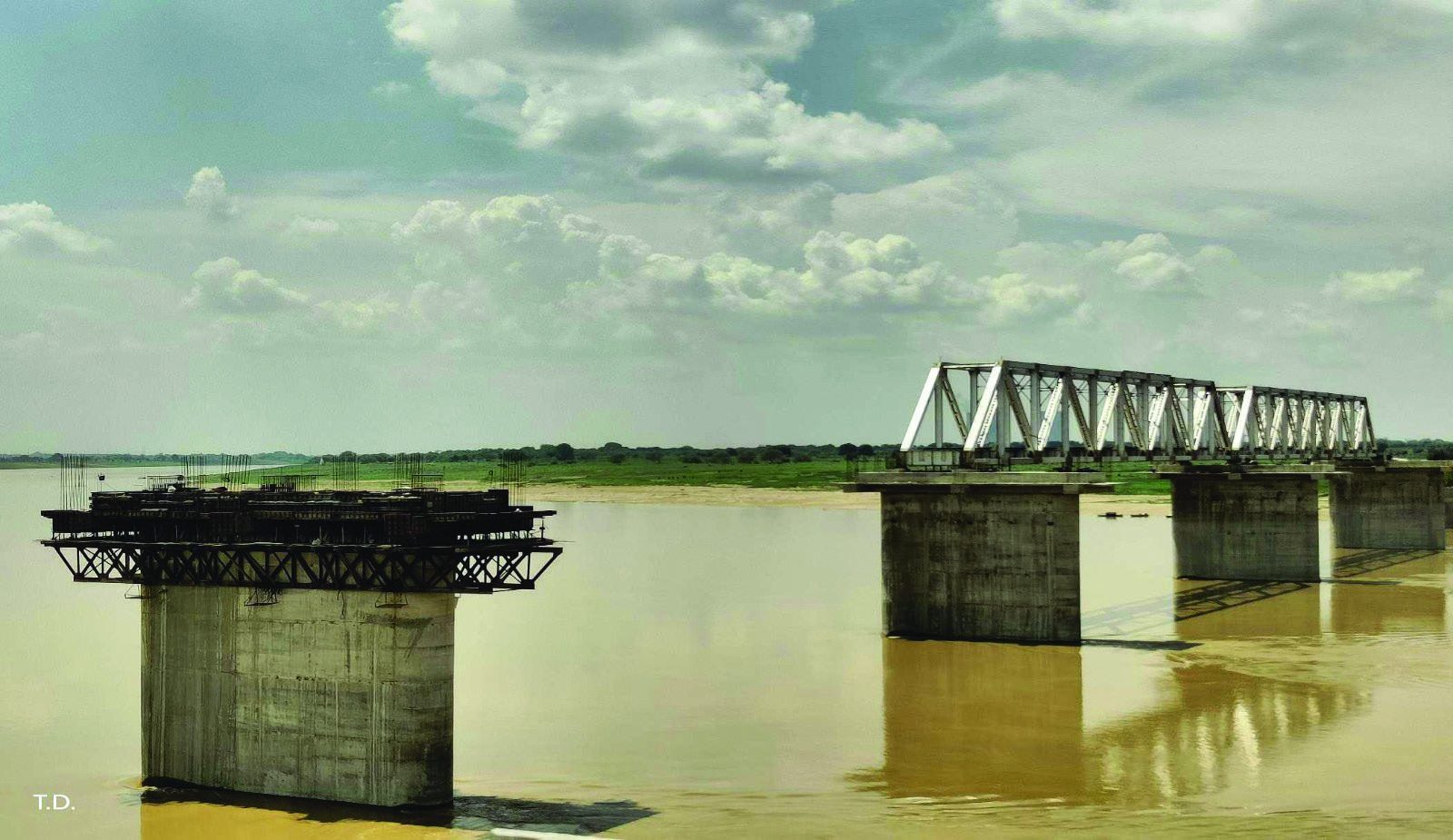
Construction of Major Bridge No. 1367 /2 across the Yamuna River, comprising 12 spans of 76 .2 m open web girders for single line over substructure designed for a double line, including earthwork and protection works, in connection with the Khairar - Bhimsen doubling project.
The values mentioned are based on the sub-soil profile and properties as encountered in the soil investigation work carried out before the start of the detailed execution design. Uniform soil properties were considered in the foundation design of all the well foundations of the proposed bridge assuming that no difficulty would be encountered in sinking down the well foundations upto the approved design founding level.
Documents Referenced:-
Codes: IS 3955-1967, IRC 45-1972 , and IRS Manual.GAD Drawings: No. 2020-21 /J-89 1/02, Revision R0 (Sheets 1, 2 , 3 ).
Structural Drawings: No. 2020-21 /J-89 1/03, Revision R0; No. 2020-21 /J-89 1/14, Revision R0.
Geotechnical Report: Particle Size Analysis for Scour Depth and Lateral Stability of Pier P3.
Site Data: Certified foundation levels for wells .
Structural Design: Excel sheet and Certified Site Existing foundation RLs.
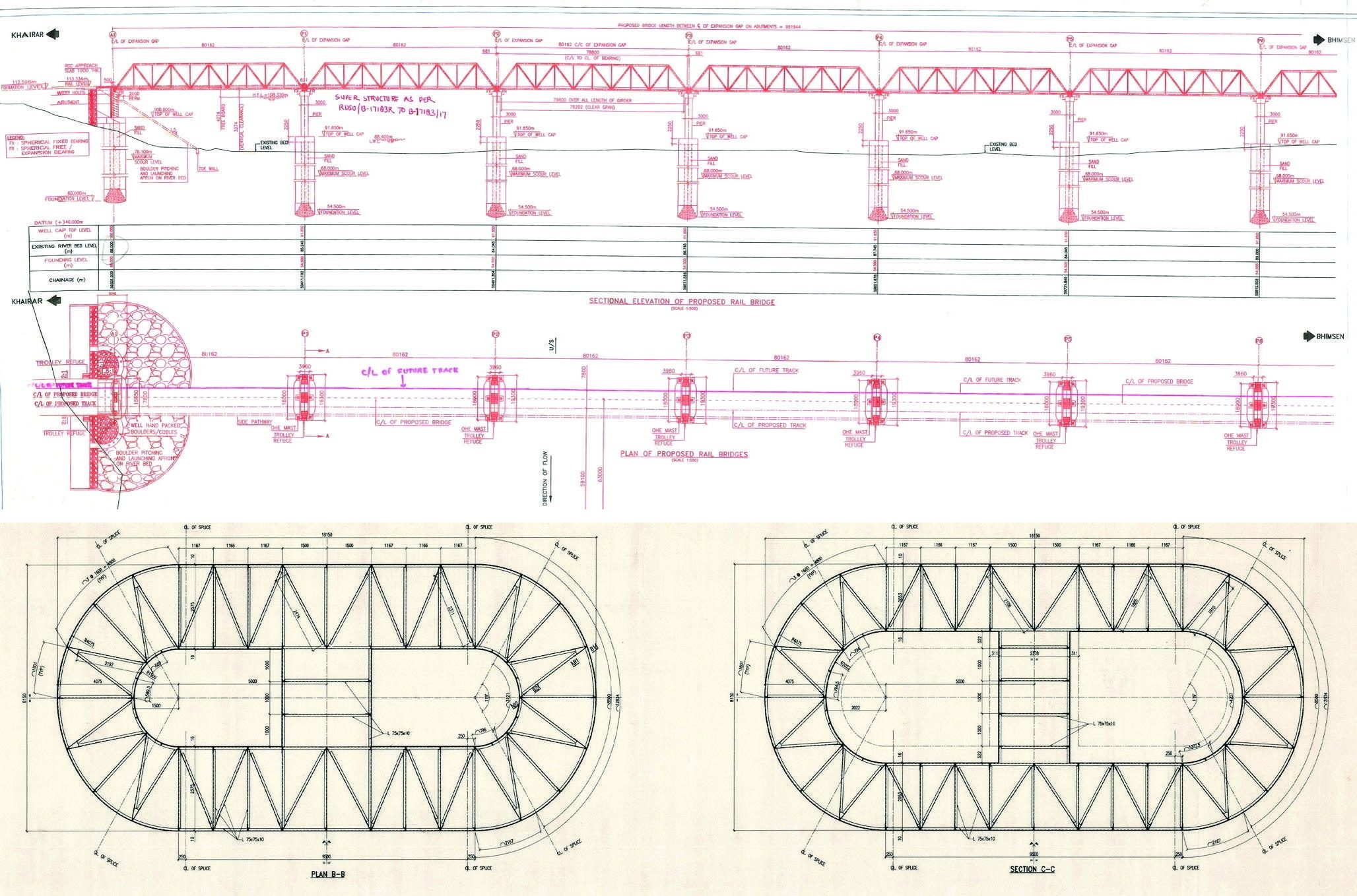
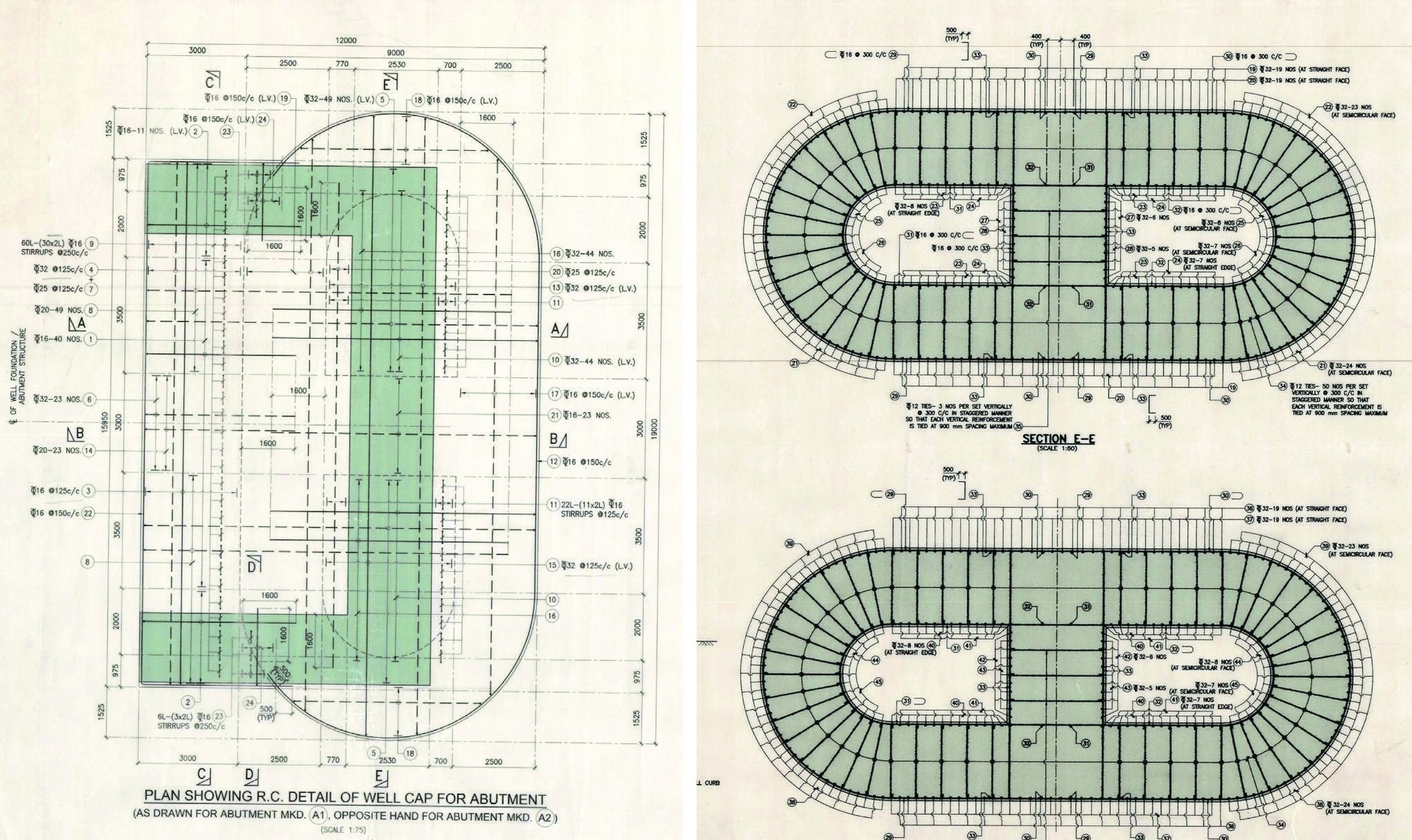
The design calculation of the Double-D well foundation for piers of the proposed rail bridge no. 1367/2 over the river Yamuna in Uttar Pradesh was presented vide Design Note Number 2020-21/J-891/ DN-01 Rev. 0. The details of the Double-D well foundation for the piers ware shown in Drawing No. 2020-21/J-891/03 Rev. 1. The Hydraulic Calculation for the bridge was given in the Annexure-2 of the approved Design Basis Report (DBR). As per the Hydraulic Calculation mentioned above, the design scour level for the pier well foundations was calculated at RL 68.000 m with value of silt factor of 1.505. The highest possible founding level as per the above Hydraulic Calculation was calculated at RL 54.500 m, after providing the minimum grip length as mentioned in clause no. 6.9.1 of the IRS Bridge Sub-structure & Foundation Code. There are 11 number piers for the bridge between the two abutments. The founding level for the well foundation for piers was originally designed at RL 52.000m.
Sinking of the Double-D well foundation for the pier marked. P3 was started following the approved Drawing No. 2020-21 /J-891/03 Rev. 1. However, after the cutting edge had reached RL 56 .000 m, further sinking could not be advanced in spite of adopting all possible efforts including sending divers with chisel hammers below the water level inside the dredge hole of the well, due to the presence of hard clay stone / sand stone at that level. The effort to take the well foundation further down was continued for months but without any progress. As the RL 56.000 m where the well got stuck is above the highest possible founding level of 54.500 m as per the hydraulic calculation submitted in the approved DBR, it was considered necessary to carry out a fresh geotechnical investigation in and around this well foundation and then revisit the design calculation with the findings of the fresh geotechnical investigation report. As a part of this exercise 10 new boreholes were drilled upto 60.0 m depth below the river bed level, one at pier marked. P1 location, four at the four corners of the well marked P2 location, four at the four corners of the well marked P3 location and one at pier marked P4 location, also 10 numbers borehole were therefore drilled in around the pier foundation under consideration to ascertain the following parameters for redesign of the well foundation for the pier marked P3.
1.) Silt factor of the bed material to recalculate the hydraulic parameters for this particular foundation including the design scour level and the highest possible founding level for the well foundation after providing the minimum grip length below the design scour level as mentioned in clause no. 6.9.1 of the IRS Bridge Sub-structure & Foundation Code.
2.) The gross safe bearing capacity at RL 56.000 m where the cutting edge of the well foundation got stuck and could not be advanced.
3.) The settlement at the above level for the imposed vertical load from the well foundation, if the well can be founded at RL 56.000 m, where it got stuck and could not be advanced.
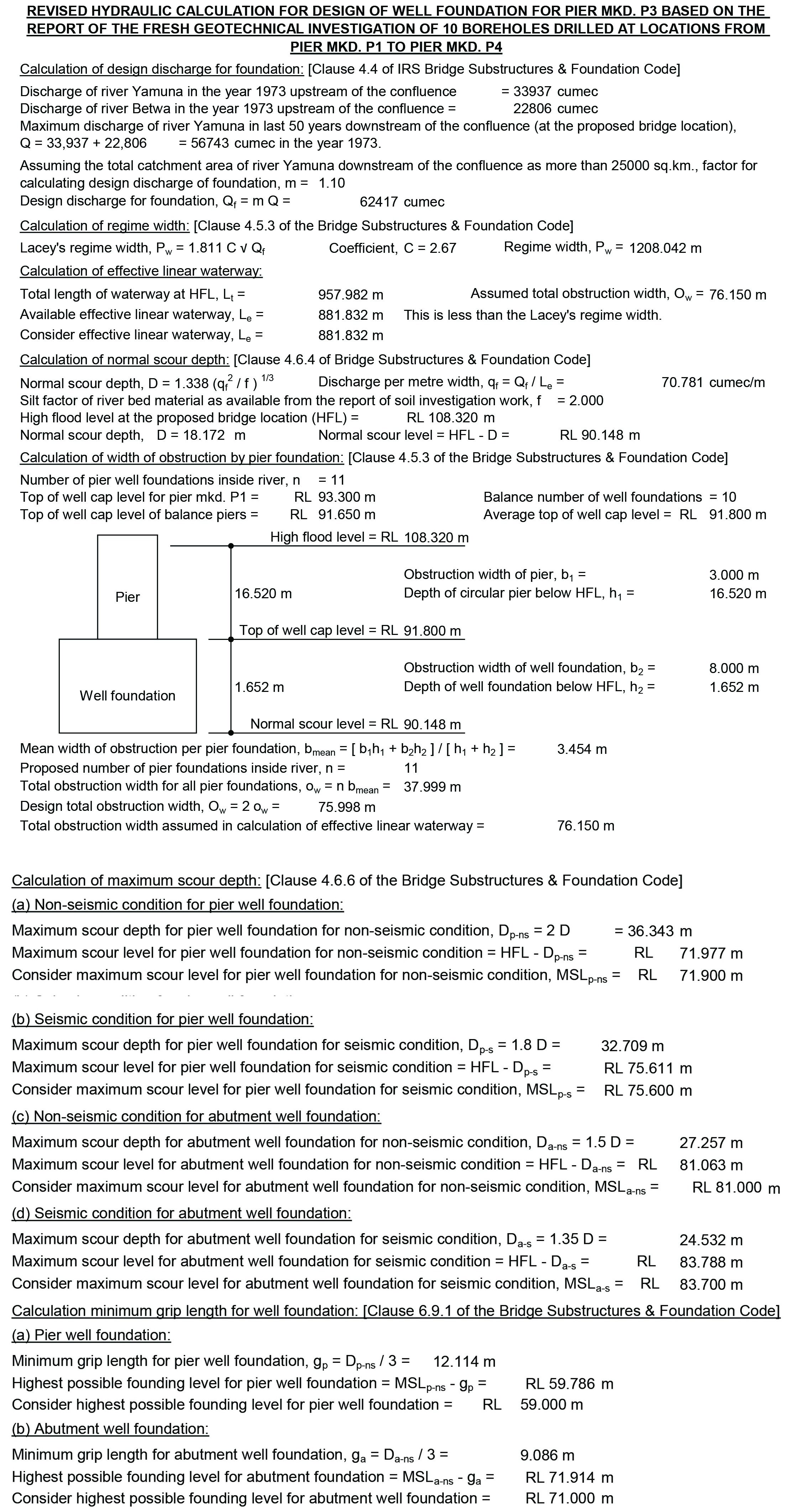
The report for the geotechnical investigation freshly carried out at the 10 locations stated is attached with this calculation. It can be seen from the report that the average silt factor for the 10 boreholes drilled from the pier marked P1 to the pier marked P4 location is 2.138 which is higher than the value of 1.505 considered earlier. The hydraulic calculation has been revisited with a silt factor of 2.0 on the conservative side. The revised hydraulic calculation is attached as Annexure of this Design Calculation. From the revised hydraulic calculation, it can be seen that the design scour level for the well marked P3 is at RL 71.900 m., and the highest possible founding level after providing the minimum grip length below the design scour level is at RL 59.000 m.
The design calculation of the Double-D well foundation for the pier marked P3 was separately presented, in light of the revised hydraulic calculation attached to this note, prepared based on the interpretation and the findings of the salient design parameters available in the report of the fresh geotechnical investigation report for the 10 boreholes stated above (i.e. silt factor value as 2.0, maximum scour level is at RL 71.900 m and the highest possible founding level for the well foundation is at RL 59.000 m). It is observed that with the revised design parameters as stated above, the well foundation for the pier marked P3 is safe from the stability, bearing capacity and settlement considerations as laid down in the "IRS Concrete Bridge Code", "IRS Sub-structures and Foundation Code and "IRS Well and Pile Foundation Code" with the founding level at RL 59.000 m (i.e. at the highest possible founding level after providing the minimum grip length below the design scour level as calculated in the revised Hydraulic Calculation).
As the well foundation for the pier marked. P3 has already gone down by 3.0 m below the calculated safe founding level at RL 59.000 m, it is concluded that the well foundation may be allowed to plug at bottom the present cutting-edge level.
Geological Observations
As sinking occurred at a negligible rate of 9.3 mm/day to zero, the Termination of the Well Foundation may be allowed.Recommendation
During driving/sinking of the well foundation, hard strata (stone/ sand stone) were encountered and beyond RL 55.925 m, no further sinking was physically possible. This impediment called for forced termination of well foundation for pier marked P3 at RL 55.925 m, provided such rise in the founding level meets and satisfies all the design stipulations given in the different IRS codes. In the approved GAD of the proposed bridge, founding level of this well foundation was proposed at RL 54.500 m. Therefore, a fresh geotechnical investigation was done in consultation with the N. C. Railways, around the outer periphery at four corners of the well foundation under consideration. Based on the investigation report of this fresh soil investigation, the expert geologist recommended the value of silt factor of the river bed material as 2.0 which is higher than the value of 1.505 considered earlier from the report of the soil investigation work carried out before the start of the structural design of the well foundations. This increase in the value of the silt factor as recommended in the fresh soil investigation report was instrumental in raising the design scour level vis-a-vis the minimum required founding level and permitting the actual rise in the proposed foundation level of the well foundation from RL 59.0 m to RL 55.925 m. The well foundation is therefore allowed to terminate at RL 55.925 m.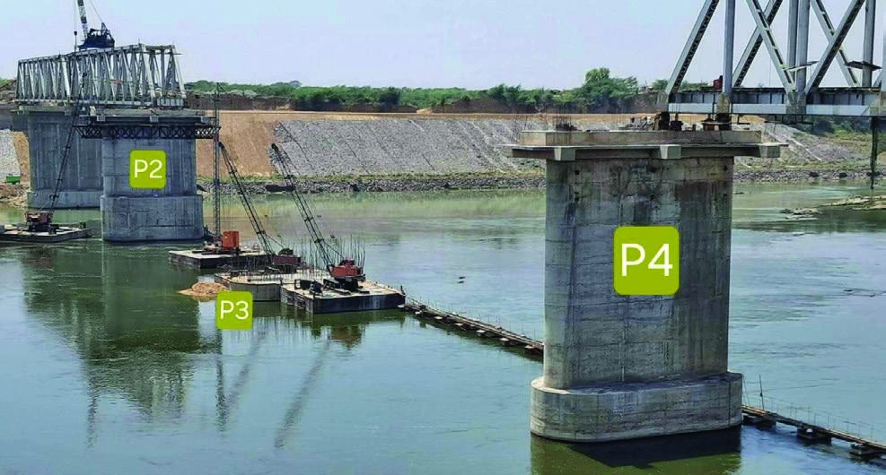
Photos below showing the ongoing Construction of Major Bridge No. 1367 /2 across the Yamuna River, comprising 12 spans of 76.2 m open web girders for single line over substructure designed for double line, including earthwork and protection works, in connection with the Khairar - Bhimsen doubling project.
About the Authors:

Bhupendra Singh Thakur, Design & Review Expert, North Central Railway General Consultant, RCPL Prayagraj, Uttar Pradesh.