Digital Visualization Keeps Interstate 81 Project on Course
Record-breaking traffic jams, accidents, and never-ending road maintenance conjure up scenes in midtown Manhattan, not in northern New York. However, the rural New York towns of Pamelia and LeRay and nearby Fort Drum Army Base were in the midst of their own critical transportation needs.
The existing highway network—I–81, US Route 11, and NYS Route 342–was established well before the current expansion of the 10th Mountain (Light Infantry) Division Army Base. The roadways have been stressed by the combination of local traffic and traffic generated by military and civilian personnel entering and exiting the base. Plus, a number of commercial establishments were built along these highways as a result of the additional base personnel.
Because of the changes in the area, Route 342 currently carries the highest traffic volumes for any two-lane highway in the five-county area serviced by Region 7 of the New York State Department of Transportation (NYSDOT). These high traffic volumes are contributing to increased accident rates, lowered levels of service, intermittent capacity issues, and increased maintenance efforts and expenditures for both Route 342 and Route 11. But the biggest reason was that something needed to be done to maintain the strategic viability of the base while improving overall regional mobility.
The need for a solution to the existing traffic situation and a far superior military route to Fort Drum resulted in the high-profile, complex, transportation project of National Security known as the Fort Drum Connector Project. The primary goal of this project–forecast for completion in 2010 at a cost of $63 million–is to provide a new, four-lane connector constructed on new alignment from I-81 to Fort Drum.
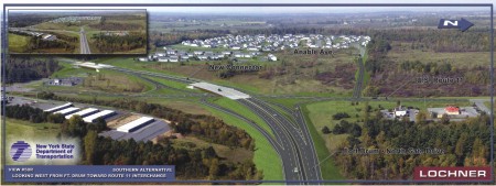
Being named a federal, high-priority SAFETEA-LU project and NYSDOT Project of Statewide Significance elevated the project’s importance on a statewide and national level. But NYSDOT needed a way to explain the design of the three proposed alternatives as well provide the community a way to understand the purpose and need of the project.
Lochner, Inc. was tasked with developing digital visualizations, which were critical in the early phases of project development when presenting proposed alternatives to the community and other stakeholders. At the critical public hearing for the project, visualizations were presented to communicate how the project would look post - construction.
Views of the three feasible proposed alternatives were depicted as well as a visualization of the single-point interchange at the west end of the project. 3D MicroStation design files contained gridded representation of both the existing and proposed digital terrain models of the roadways, and aerial photos taken from a helicopter at predetermined locations and directions were then photomatched with these design files to provide the base for visualization.
"While the visualizations were being prepared, we resolved constantly changing roadway alignments with digital terrain models," explained Mark Pawlick, Lochner vice president. "The use of MicroStation, InRoads, and ProjectWise allowed us to work with NYSDOT as if we were in the same office."
ProjectWise provided the perfect vehicle for the transfer of up-to-date information among the NYSDOT design team and the Lochner engineering visualization team. The visualizations also helped show how the new connector would look after construction in an area where no roadway currently exists. "The ability to photomatch aerial photos with MicroStation design files for realistic perspective was critical. Having this ability saved the eight people on the Lochner visualization team untold hours," Pawlick said.
Published on:
15 April 2009
Published in: NBM&CW April 2009
Share:
We Value Your Comment