DGPS Survey for Infrastructure projects
Use of DGPS for road/highway projects
In earlier times, the surveyors used the traditional method to find the bearings of a line by observing stars like the sun. Now the technology of DGPS is widely used to fix the points accurately to have a complete horizontal control with the WGS (World Grid System). These points ensure that further traverse legs are reckoned and closed with a pair of GPS points already established. Thereby surveyors are also confident of the open traverse conducted and a need to re-check the traverse is eliminated.
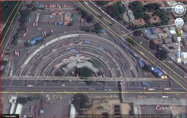
Google earth integration
With the google earth technology, we are even more confident of the surveyed loops and topographical features. As the interest developed with the UTM coordinates which are already available with the GPS technology, Integration with Google earth became much necessary to visualize the surveyed topographical features. On these lines several applications are developed to overlay the surveyed drawings into Google earth and back. One such application "KML Module" is developed by ESurveying softect which is a more convenient way for the interface. It easily transfers the drawings into Google earth and back to a drawing application with or without any modifications. It also facilitates the user to create drawings components like lines, polygons with the text to be created in Google earth and directly export to drawing applications without losing its Geo locations and UTM Projection.
Published on:
12 December 2014
Published in: NBM&CW December 2014
Share:
We Value Your Comment