Turkey's Tough Geology Inspires Robust Machine Design
By The Robbins Company
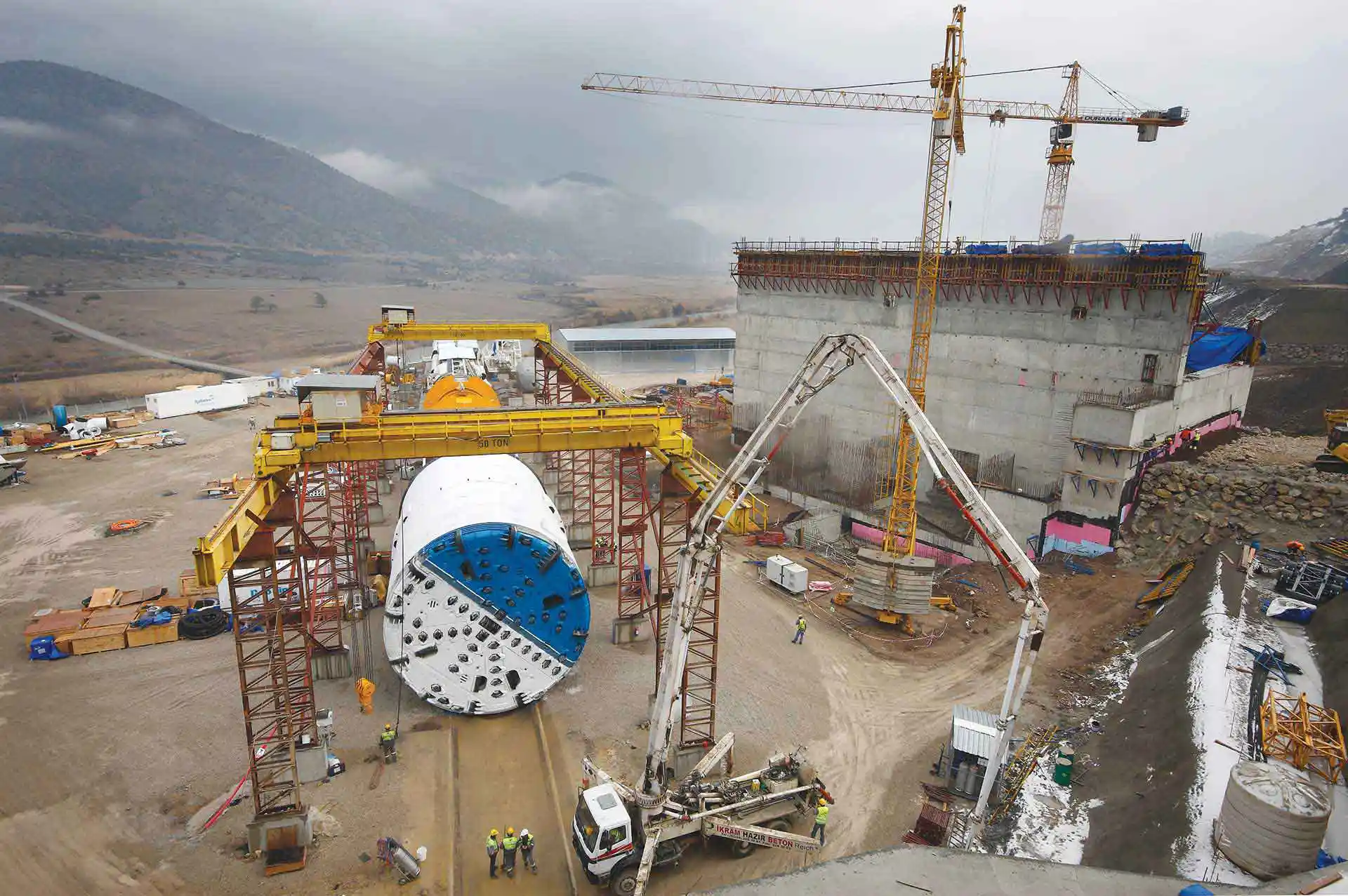 The 10 m diameter Double Shield TBM was launched in 2012 from a jobsite in mountainous Central Turkey near Ankara.
Driven through a mountain side with 600-m of cover in Central Turkey, the Kargi Kizilirmak Hydroelectric Project is one of the most challenging tunneling projects ever completed in the region. The project is located on the Kızılırmak River, near the Beypazarı district of Ankara province in Turkey. The Kızılırmak (Turkish for “Red River”), also known as the Halys River (Ancient Greek), is the longest river in Turkey. The project includes a 13-m high, 450-m wide earth dam with a concrete spillway in the southern end and a water intake construction on the northern side. The dam creates an artificial lake with a high-water head of 405 meters above sea level. A headrace tunnel diverts the water from the dam to the powerhouse situated east of the village of Maksutlu. The water from the powerhouse will flow into the Boyabat reservoir at 330 meters above sea level. Once online, the project will generate 470 GWh of power annually for project owner Statkraft, an amount sufficient to supply approximately 150,000 homes.
 The original geological report called for softer ground for the first 3 km, followed by 8.8 km of unlined tunnel in competent rock.
Initial Machine Supply & Geology
The project area is located within the Northern Anatolian Fault System, which is primarily responsible for earthquakes in Turkey. The tunnel was driven through a mountain side with up to 600-m of overburden. The expected geology along the tunnel alignment consisted of Kırazbası complex Kargı ophiolites (including sandstone, siltstone and marl) for the initial 2,300 meters, followed by 1000 meters of Kundaz metamorphites (including marble, metalava and metapelite), and the remaining 8,500 meters consisted of Beynamaz Volcanites (including basalt, agglomerates and andesite). The anticipated strength of the rock was up to 140 MPa. Multiple fault zones and transition zones added to the complexity of the geological conditions.
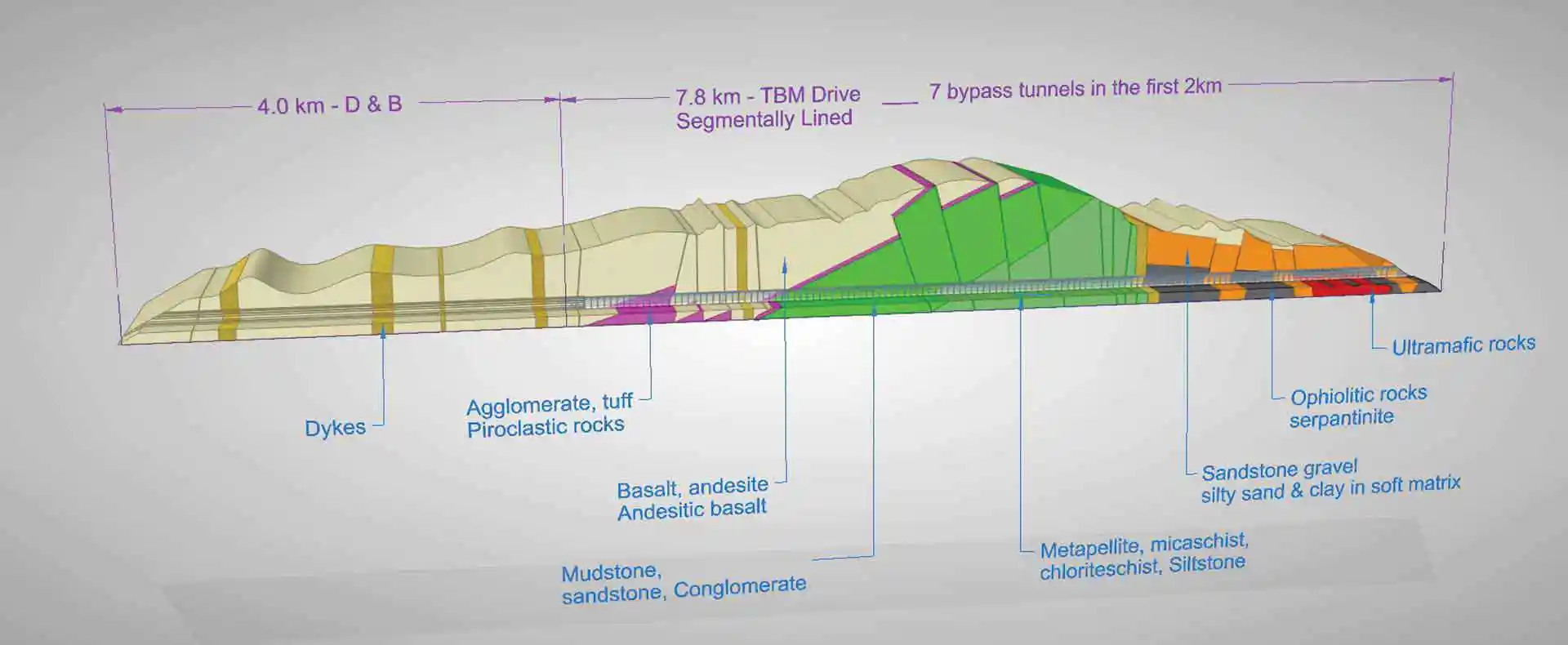 By the time the project was 50% complete, the geology was recognized as vastly different. Multiple fault zones and collapsing ground resulted in seven bypass tunnels within the first 2 km. The entirety of the TBM-driven tunnel required segmental lining.
The Robbins Company supplied a 9.84-m diameter Double Shield TBM and continuous conveyor system to Turkish contractor Gülermak for excavation of the 11.8-km headrace tunnel in 2012. Initial geological reports predicted softer ground for the first 2.5 km, which would be lined with pre-cast concrete segments. The remainder of the tunnel was to be supported by a combination of shotcrete, rock bolts, and wire mesh.
Excavation & Difficult Geology
The machine almost immediately encountered geology that was substantially more problematic than was described in the geological reports. The geology consisted of blocky rock, sand and clays. “The Kargi TBM was launched into poor geology in early 2012. After boring 80 meters, the TBM became stuck in a section of collapsed ground that extended more than 10-m above the crown, loaded onto and around the cutterhead,” said Glen Maynard, Robbins Site Manager. As a countermeasure that was immediately put into place to avoid the cutterhead becoming stuck in the blocky material, crews began boring half strokes and half resets.
Published on:
09 October 2019
Published in: NBM&CW October 2019
Share:
We Value Your Comment